Dead Horse Point sunset. This is where the cowboys would corral the mustangs at the ledge.
 |
| Cedar City boondocking campsite. |
When leaving western Colorado into Utah there wasn't much along the way to Dead Horse Point State Park just outside of Moab. For one part of the drive, there were no exits or service stations for 110 miles. This was much like Wyoming. The landscape along the drive is valleys and mountains (including rock formations) in an arid environment (hot, in the high 90's).
Dead Horse Point State Park is just 20 miles from Moab. The road culminates to a point where you can see the Colorado River and canyon below. The legend of Dead Horse State Park is cowboys would direct the wild mustangs towards the point which they set up a corral to pin the stallions. The rustlers would pick the horses they wanted and would leave the rest in the corral without exiting. Terrible legend but wouldn't be surprised, if true!
So lets start with the area only getting 10" of rain per year. The type of plants that survive in this environment can go dormant until the rain comes. I am grateful we had electrical to run A/C!
So why do people come to this type of environment? Colorado River trips and ATV/Jeep/Hummer tours are big. From the top of Dead Horse State Park you can see trails below where you can ride thru the canyon. I could have taken the truck down into the trails but smarter mind prevailed (Kami). There is one trail that is 100 miles long that you would need to have tent and food overnight to complete the trip.
Moab is the small town that has recreational vehicles and river tour companies. The town is much like other towns next to the Colorado River with trees and grass from water pumped in from the Colorado. It looks like a oasis. The day we were there the temperature reached 106 degrees.
Also in the area are Arches National Park and Canyonland National Park. Arches is just before Moab and known for, you guessed it, arches and rock formations. Canyonland is in the same area as Dead Horse State Park (know for the beautiful canyons and ability to go down into the canyon to 4x4).
Our next stop was Bryce Canyon further West. The landscape started changing with more trees and vegetation. It even rained several times while we were there from Monsoons coming up from New Mexico this time of year. The weather was more accommodating with 80's during the day and 60's at night. Nice break from the heat we endured for several weeks.
So Cedar City was not on our list . We were actually supposed to go down to Zion National Park but Kami's teeth, which she has had issues since January, came to a head and the pain became unbearable. We diverted our trip to Cedar City which was the closest with multiple dentist. Fortunately Kami found a dentist that was able to find the cause of her pain. She needed a root canal inside a crowned tooth. This is tricky as the dentist needs to drill into the crown to pull the dead roots out. If the crown is cracked we have a whole other issue. We got there Thursday and the dentist was able to drill thru, pull the dead roots out, and add antibacterial medicine to clear the infection. On Monday, the medicine was pulled out and the root was replaced and crown sealed. Crossing our fingers Kami is good!
So while in Cedar City, we boondocked in recreational area for 4 days. It's a good size city where Southern Utah University is located......about 15,000 students. We ran into a couple of students on one of our trail hikes at the recreational area we stayed. I went ahead and had my truck tires replaced while in Cedar City. I knew I would have to get it done soon and it just worked out while we were there.
Pic above was 50 yards from our campsite. Literally, Dead Horse Point comes up to a point above the canyon. Pic to right is Colorado River from Dead Horse Point. If you look closely to the bow in the river, you can see a trail coming from it. That is Part of the 100 mile trac you can take down in the canyon.
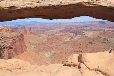
Pic above peering thru archway into canyon from Canyonland National Park. Pic to right is from Canyonland. There are trails down there for you to hike or ride.
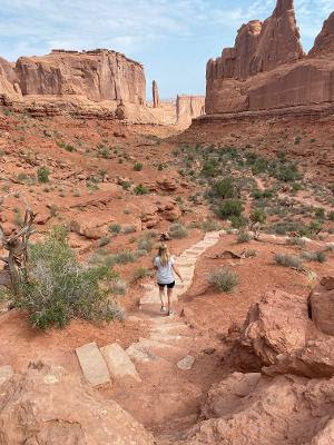
Pic above is one of the more famed delicate arch. Pic below is Kami starting the hike thru the formations. It was hot but we started in the morning. For the Arches National Park you need to reserve your time to get in. This is one of the few that does this since it's a popular destination. There were quite a few turning around from the gate since they didn't have a set time. Most of the times were sold out. We booked a couple of months in advance.
This was early morning at Arches National Park. The weather was still in the 70's.
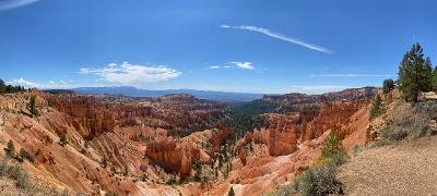
Bryce Canyon, we hiked down into the area below. I was stopped by a Park Ranger recommending I take a water bottle on our trip. Kami had one and I pointed to her. The Ranger was still concerned about dehydration but the temperature at the time was 69 degrees with a high of 80 that day. We had literally walked in 100 degree temperature days prior. There were several people on the hike that were laboring and I get why the Ranger was doing their job.
Pics of hiking trails taken while at Bryce Canyon.
There seems to be a theme with rock formations with holes. What do you think?


Comments
Post a Comment